
Scotland (Parliament Politics Magazine) – The Met Office has named Storm Bram, issuing amber warnings for wind in north-west Scotland with gusts to 90mph and rain in Devon, Cornwall, and south-east Wales, alongside yellow alerts forecasting flooding, transport chaos, and danger to life from Tuesday. Named by Met Éireann, the storm stems from a potent jet stream, with heavy rain up to 100mm possible on saturated ground, prompting urgent preparation across the UK.
Storm Bram Named Amid Severe Weather Alerts
The Met Office has officially named Storm Bram, with amber warnings for damaging winds and heavy rain set to batter the UK from Tuesday, posing risks of flooding, power cuts, and life-threatening conditions. Multiple yellow warnings complement the ambers, covering rain and wind across England, Wales, Scotland, and Northern Ireland from Monday to Wednesday.
As detailed by BBC Weather, damaging winds and flooding rain will sweep the country, with chief meteorologist Simon King explaining the impacts. The storm, named by Ireland’s Met Éireann, arises from a low-pressure system driven by a potent Atlantic jet stream.
Deputy chief meteorologist Dan Holley of the Met Office stated: “While there is some uncertainty regarding the precise path and strength of the low-pressure area as it approaches western Scotland later on Tuesday, numerous regions in the UK are likely to experience rainfall spells which, combined with saturated ground, could lead to flooding and delays in road and rail travel. Furthermore, strong winds are anticipated, especially in northern and western areas. We are closely observing the situation and may provide updates to the warnings as it develops.”
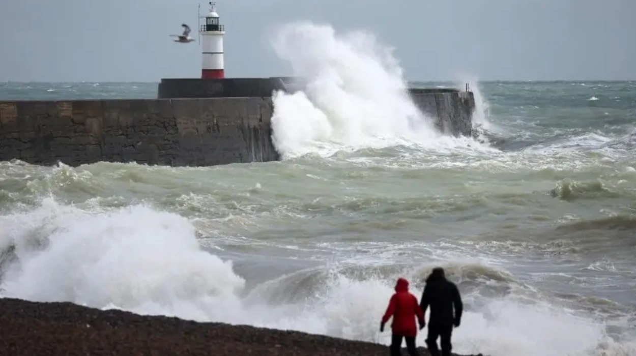
Amber Wind Warning Details
An amber wind warning covers north-west Scotland from 1600 to 2300 BST on Tuesday, with gusts reaching 90mph (144km/h) in exposed spots. The Met Office warns of flying debris creating life-threatening situations, road and bridge closures, railway disruptions, power outages, and structural damage to buildings.
Yahoo News UK reports strong winds broadly across the region, with potential delays and cancellations in transport networks alongside building damage. BBC News highlights the danger to life from such conditions.
Amber Rain Warnings Issued
Two amber rain warnings activate from 0000 to 1000 GMT Tuesday: one for Cornwall and Devon, another for south-east Wales. Expect 50-75mm of rain in nine hours, up to 100mm in exposed hills over half December’s average leading to fast or deep floodwaters endangering lives, isolated communities, flooded roads, and power cuts.
A broader yellow rain warning spans Wales and south-west England from 1800 Monday to 1800 Tuesday, forecasting 20-40mm widely and 80mm on Dartmoor or Welsh hills. Saturated ground from prior rain exacerbates flooding risks.
BBC News issued a ‘danger to life’ warning, noting communities could be cut off by floods.
Additional Yellow Warnings Overview
Yellow wind warnings include Dorset and Cornwall from 2200 Monday to 1600 Tuesday, stretching along England’s south-west coast to west Wales, with risks to power, transport delays for high vehicles, and coastal hazards from spray and waves.
Multiple yellow rain and wind alerts persist Monday-Wednesday nationwide, per Met Office maps shared by Yahoo News UK. The UK warnings page lists active alerts for rain, wind, snow, ice, fog, thunderstorms, and heat, though Storm Bram focuses on wind and rain.
Regional Forecasts and Impacts
South West England: Mainly dry and bright early Monday with brisk winds, clouding over with showers by afternoon; maximum 14°C. Tuesday starts windy with heavy rain clearing to cloudy, then clearer from west; maximum 14°C.
Wales: Early showers clear to dry morning with sun; afternoon cloud and showers; maximum 12°C Monday. Tuesday cloudy with morning rain/drizzle brightening; maximum 16°C.
North East: Dawn rain/showers clear to dry with sun; afternoon showers; maximum 11°C Monday. Tuesday wet and windy improving to drier/brighter; maximum 15°C.
North West: Early showers to dry with sun; maximum 12°C Monday. Very wet Tuesday start turning drier; maximum 16°C.
Wednesday-Friday Outlook: Drier and brighter Wednesday with sun; Thursday dry with bright spells, possible Friday rain. North East blustery showers Wednesday easing Thursday; North West sunny spells and heavy showers Wednesday, dry Thursday, rain Friday.
BBC coverage anticipates widespread transport disruptions, home/business damage, and localised flooding especially in Wales and south-west England.
Storm Naming and Meteorological Context
Storm Bram marks the next in the sequence named by Met Éireann and Met Office for impactful Atlantic lows. The Met Office media centre confirmed strong winds and very heavy rain for northern/western UK, with ambers issued.
Previous BBC articles note Storm Bram bringing strong winds and widespread rain, with amber rain for Wales. Unsettled weather persists due to the jet stream ushering low-pressure systems.
Preparation and Safety Advice
The Met Office urges monitoring updates as the storm evolves, given path/strength uncertainty over western Scotland. Warnings emphasise avoiding coastal areas, securing property, and planning for travel disruptions.
Yahoo News UK maps visualise the warnings, stressing possible life-threatening debris and flooding. BBC Weather advises on severe alerts’ implications.
No specific statements from government officials or emergency services appear in initial reports, though standard Met Office guidance applies: check travel, avoid floodwater, prepare for outages.
Broader Implications
Storm Bram highlights ongoing wet, windy autumn/winter patterns, with saturated grounds amplifying flood risks. Coverage spans BBC, Met Office, and Yahoo, underscoring national scope from Scotland to south-west England.
As conditions unfold Tuesday, further updates expected; residents urged vigilance amid potential for power disruptions, isolation, and structural impacts.