
Atlanta (Parliament Politics Magazine) January 18, 2026 – A rare winter storm battered the southeastern United States on Sunday, depositing seldom-seen snow in Florida, Georgia, and Alabama. Winter storm warnings blanketed northwest Florida, central and southwestern Georgia, and southeast Alabama, forecasting up to three inches of accumulation. The expansive system stretched 1,500 miles north to Maine, triggering advisories from the Mid-Atlantic to New England, with New York City expecting two to four inches and Boston up to six inches.
Snowfall commenced early Sunday in regions rarely touched by winter precipitation, as arctic air from Canada drove temperatures down and transformed rain into flakes. Forecasters highlighted the storm’s exceptional length, blanketing palm trees in the South amid widespread road hazards along the East Coast.
Winter Storm Warnings Target Southeast Hotspots

Winter storm warnings were activated in northwest Florida’s panhandle, anticipating up to two inches of snow by Sunday morning, per National Weather Service alerts. As reported by Amy Graff of The New York Times, these warnings persisted through the northwest Florida panhandle, where light snow appeared as far south as the area.
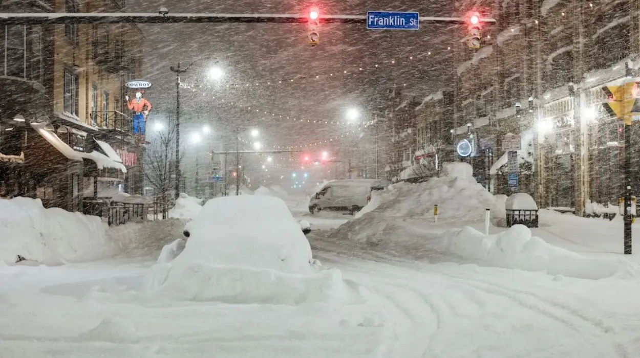
Central and southwestern Georgia, encompassing Macon and Dublin, plus southeast Alabama, held warnings until 1 p.m. Sunday, with up to three inches projected. Ben Noll of The Washington Post specified rare winter storm warnings for central Georgia south of Atlanta, expecting several inches of heavy, wet snow near Macon.
Early Sunday, light snow fell in Mobile, Alabama, and Baldwin County. The Atlanta National Weather Service office verified snow onset in Columbus, Georgia, noting rain between Columbus and Macon swiftly converting to snow.
Local meteorologists provided updates on the evolving pattern. Brad Nitz of WSB said in an X post,
“Friday update: snow in Georgia Sunday is most likely going to set up just to our south. Although there may be a few flurries or light/brief snow showers in our southern counties, Middle Georgia is the most likely area to have snowfall. I’ll be tracking this live on Channel 2.”
Friday update: snow in Georgia Sunday is most likely going to set up just to our south. Although there may be a few flurries or light/brief snow showers in our southern counties, Middle Georgia is the most likely area to have snowfall. I’ll be tracking this live on Channel 2. pic.twitter.com/GKEBIObuYY
— Brad Nitz (@BradNitzWSB) January 16, 2026
Lindsay Marlow, meteorologist at the National Weather Service Peachtree City, Georgia, office, cautioned that Macon roads, the largest warned city, would slicken, especially untreated smaller routes. Ms. Marlow remarked,
“The chances for snow in Atlanta are low, but not zero.”
Georgia precipitation shifted from Saturday rain to Sunday snow as temperatures plunged.
Northeast Prepares for Prolonged Snow Event

Northeast snow arrived from Sunday morning into late night. Forecasts for New York City indicated two to four inches, Boston three to six, according to Amy Graff of The New York Times.
Eastern Massachusetts, eastern Connecticut, and Rhode Island faced up to eight inches. Joe Wegman of the Weather Prediction Center characterised New York’s snow as extended light rates rather than intense bursts.
Advisories spanned Philadelphia to Boston and Portland, Maine, citing road slipperiness. Western South Carolina, North Carolina, and Virginia anticipated about a tenth of an inch, with northern Virginia, Washington, D.C., and Maryland up to two inches.
Mid-Atlantic snow started early Sunday, advancing to southern New England.
Model Updates Highlight Georgia Snow Intensity
Advanced weather models refined predictions for southern snow bands. Mitch West, a meteorologist, observed in an X post,
“12z HRRR is showing heavy snow in Georgia & heartbreak for snow lovers into the Carolinas. Seems like the atmosphere has no creativity & just keeps hitting the same areas. This area was hit hard last Winter. (yes, I am throwing some emotion into this).”
12z HRRR is showing heavy snow in Georgia & heartbreak for snow lovers into the Carolinas.
Seems like the atmosphere has no creativity & just keeps hitting the same areas. This area was hit hard last Winter. (yes, I am throwing some emotion into this) pic.twitter.com/bcPQI4m00L
— Mitch West (@SCweather_wx) January 17, 2026
This aligned with reports of heavy snow potential in Georgia, contrasting lighter Carolinas outcomes.
Storm Dynamics Drive 1,500-Mile Snow Swath
A Gulf-formed storm drew northward moisture against southward-spilling Canadian arctic air. Amy Graff of The New York Times detailed the coastal system’s Atlantic path parallel to the East Coast, targeting northern New England Sunday night before entering Canadian Maritimes, Atlantic Canada, and Nova Scotia Monday.
Frank Pereira of the Weather Prediction Center described forecasting difficulties, as models varied. Mr. Pereira reported Saturday evening that recent runs strengthened the Northeast signal, particularly southern New England, saying,
“The potential for impactful snow is going up.”
Mid-week jet stream shifts ushered cold air south, producing East Coast below-normal temperatures. Joe Wegman noted these levels sufficed for snow in atypical locales, adding the Southeast often skips winters without it.
Ben Noll of The Washington Post underscored the 1,500-mile Florida-to-Maine snow corridor, a rare phenomenon.
Impacts Span Regions with Travel Warnings

panhandle snow recurred for the second year, advisories predicting palm tree coatings Sunday morning.
Southeastern Alabama encountered early flurries under advisories. Georgia zones like Macon geared for heavy, wet accumulations hindering travel.
Northeast and Mid-Atlantic officials warned of hazards on untreated surfaces. Nazaneen Ghaffar aided The New York Times reporting.
National Weather Service maps depicted snowfall odds from under 0.1 inches to exceeding 18 inches, refreshed 6:06 a.m. Eastern January 18 by Aatish Bhatia, Josh Katz, and Bea Malsky of The New York Times.
Progression Tracks East Coast Menace
Gulf moisture fused with cold air mass sparked initial Mobile and Columbus snow, building toward Macon.
Northeast emphasis stayed on steady, light snow per Mr. Wegman. The offshore track maximised southern New England effects before exit.
This moisture-cold interplay yielded southern rarities alongside northern persistence. Monitoring persisted amid developments.
Current Weather Conditions Reflect Storm Progress
As of 5:17 p.m. on January 18, active weather trends underscored the storm’s footprint. Searches for “weather” surged over 100,000 with 50% growth in past 10 minutes, signalling widespread monitoring.
Pensacola weather queries spiked 500+ with 200% rise 40 minutes ago, tying to panhandle snow. Atlanta weather trended at 200+ with 100% uptick hourly, amid nearby Georgia alerts.
Philadelphia and Baltimore weather each hit 100+ with 100% jumps in 30 minutes. Boston weather reached 200+ , up 50% in 30 minutes; Raleigh weather 100+ , 75% gain.
“Snow” searches climbed 200+ , 100% in 40 minutes. WGAL weather, WFSB weather trended at 200+ and 100+ respectively, with 100% and 75% increases hourly.
Atlanta Weather Update
Atlanta currently features cloudy conditions with temperatures at 35°F (1°C), 52% humidity, northwest winds of 4 mph, and 2-mile visibility under full cloud cover.
Downtown reports overcast skies at 6:53 a.m. local time, no precipitation, and 30-inch pressure, while the UV index stays at 0 overnight. Clouds yield to sun Sunday, with sunny spells through Wednesday, partly sunny skies Thursday, and partial sunshine Friday.